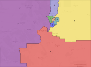
Congressional Map
Click here to explore the map on Dave’s Redistricting.
The districts we draw now will determine every Colorado community’s resources and representation for the next decade, and fair districts make communities stronger.
Historically, neighborhoods, towns and counties have been carved up by party leaders and elected officials to concentrate their power and serve their political needs. The traditional system of redistricting is notoriously exclusive, secretive, self-serving, and has cemented the electoral winners for a decade in many states. This gerrymandering has severe consequences: elections are decided before they’ve begun, voters face ballots with no candidates who represent their interests, and entire communities have elected bodies that aren’t responsive to their needs.
With Amendments Y and Z, Coloradans reclaimed the power to draw voting boundaries, creating nonpartisan, independent commissions to draw the district lines so that voters pick their leaders instead of leaders picking their voters.
Colorado Common Cause is a nonpartisan, nonprofit organization with more than 24,000 members throughout the state. We know that our democracy is strongest when everyone participates, and that’s why we were drafters and strong supporters of the amendments that made this change possible.
We’ve brought together research, expertise, and community insights to support commissioners in making fair, informed decisions.
This memo and our accompanying map are the product of dozens of community meetings and mapping sessions we conducted throughout the state. Between January and August 2021, Colorado Common Cause hosted 68 meetings for more than 1,200 Coloradans from every region of the state. We discussed the redistricting process and listened to parents, college students, retirees, business owners, immigrants, farmers, ranchers and Coloradans of all political backgrounds as they talked about the things they loved and cherished about their communities. Our map is a reflection of their stories.
Map principles:
- Prioritized Voting Rights Act compliance, communities of interest and adherence to CO Constitutional guidance to not dilute racial, ethnic or language minority groups
- Preserved rural counties, municipal boundaries and established urban neighborhoods
- Strived to create compact and competitive districts
Map Highlights:
- Reflects Colorado’s diversity by prioritizing protection of rural and agricultural communities, Native Americans, Latinos and other minority groups, regional identities and other communities of interest.
- Adheres to Colorado’s Constitution by prioritizing the voice of the people over any political party or incumbents.
- Keeps Colorado’s thriving Latino/Hispanic communities who share policy interests related to education, health, affordable housing, air quality, and transportation together.
Our maps also follow the criteria set forward in the Colorado Constitution:
- Equal population and contiguous districts
- Adherence to the federal Voting Rights Act of 1965
- Preserving whole communities of interest and political subdivisions, as much as is reasonably possible
- Compact districts
By “preserving whole communities of interest,” the state constitution requires that the commission draw districts that keep communities with common policy interests together, setting aside partisan competitiveness and archaic county borders, so everyone gets a voice in our democracy. You can see this in action in our Congressional map; it preserves the Western Slope, San Luis Valley, mountain resort communities, north and south I-25 corridors, and more.
After all the constitutional criteria have been met, only then is the commission directed to maximize the number of politically competitive districts (Colo. Const., art. V, § 44.3(3)(a)). Our draft Congressional map is made up of districts that are reflective of the communities that live throughout Colorado and contains three competitive districts.
Additionally, the constitution requires that maps cannot be drawn in a way that limits the right to vote or the electoral influence of communities of color and non-English speakers (Colo. Const., art. V, § 44.3(4)(b)). Our map creates two districts in the Denver Metro region where communities of color would have the representation necessary to influence the policies that will affect their lives. Rather than prioritizing the archaic lines of the City and County of Denver, our maps are based on modern shifts in how people have actually developed and built their communities.
The result is districts that recognize the diverse needs of the voters and residents in and around the Denver Metro area. District 7 extends from Sheridan to Brighton, encompassing a thriving Latino/Hispanic community who share policy interests related to housing affordability, air quality, and economic and educational opportunities. District 6 brings together diverse communities in Denver and Aurora who share interests around education, transportation, and housing affordability, while establishing for the first time a Congressional district in Colorado that is majority people of color. It also keeps together African American communities and the economic hubs where Black and African American businesses have flourished. Both districts reflect the expanding Latino populations that have historically lived on Denver’s east and west sides.
Drawing district maps is both an art and a science and Colorado Common Cause acknowledges that there are many ways to craft representative maps. Nonetheless, community voices are paramount to creating fair districts and we encourage the commission to prioritize our diverse communities of interest when deciding on the final maps.
Coloradans sent a strong message with the overwhelming passage of Amendments Y & Z that no matter what we look like or where we live, we all deserve to have our voices heard and our votes count. This is a once-in-a-decade opportunity to ensure fair and equitable representation for years to come–we must make it count, for all of us.